

Western Washington faces a severe flood risk next week as multiple storm systems and a powerful atmospheric river bring days of heavy rain, rising river levels, landslide danger, and widespread flooding concerns.
Forecasts Warn of Heavy Rain, Rising Rivers, and Landslide Threats
Western Washington is on alert as meteorologists warn of a severe flood risk next week, driven by a powerful sequence of storm systems and one of the strongest atmospheric rivers of the season.
Forecasters say the region will experience continuous rounds of heavy rainfall, rising river levels, mountain snow, and an elevated landslide threat beginning Monday and lasting through midweek.
A cold front pushing into the region Friday sets the stage for the transition, bringing scattered showers to the lowlands and lowering snow levels to about 4,000 feet. While this system will not cause major flooding, it will prime the landscape for significantly wetter conditions in the days ahead.
Severe Flood Risk Intensifies as Atmospheric River Approaches
The most impactful weather system is expected Monday, when a deep plume of Pacific moisture, commonly known as an atmospheric river moves inland. Meteorologists say this event could be one of the wettest the area has seen in months.
Strong winds up to 60 mph are hitting Western Washington, causing power outages and compounding the region’s severe flood risk.
Heavy rain is forecast to arrive in several waves from Monday through Wednesday, with showers continuing into Thursday. This prolonged rainfall event significantly increases the severe flood risk, particularly for communities near rivers draining the Cascades.
Although some rivers will reach action stage over the weekend, widespread flooding is not expected until the atmospheric river arrives. Once it does, numerous rivers are forecast to overflow their banks, producing anything from minor to moderate flooding.
This becomes even more concerning as it marks the first major flood event of the season, raising alarms for both emergency managers and residents in vulnerable locations.
Mountain Snow and Runoff Add Fuel to Flood Concerns
Snow is also a major part of next week’s weather pattern.
On Friday night into Saturday, the Central Cascades will see 5 to 10 inches of snow, prompting a Winter Weather Advisory. Farther north, in the Cascades of Snohomish and northern King County, up to 18 inches of snow is expected under a Winter Storm Warning.
However, the snow will not stay on the ground for long.
When warmer, moisture-rich air arrives with Monday’s atmospheric river, rising freezing levels may cause recent snowfall to melt. This snowmelt runoff, combined with heavy rainfall, will accelerate river rise and contribute further to the severe flood risk in downstream communities.
Rivers Expected to Rise Rapidly, Increasing Severe Flood Risk
From Monday through Thursday, lowland areas are projected to receive 2 to 4 inches of rain, while the mountains may receive twice that amount. Such volume is more than enough to push rivers beyond their banks.
Flooding impacts could include:
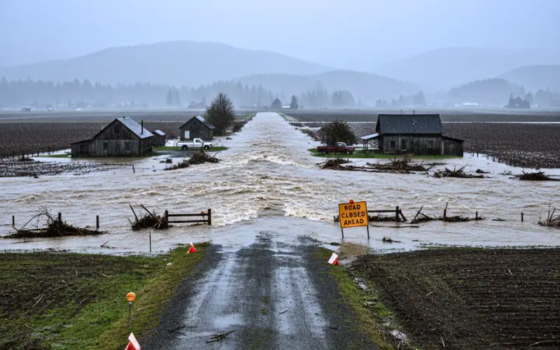
- Overflowing rivers across western Washington
- Rapid river rises from Snohomish to Lewis County
- Water spilling into agricultural zones and rural communities
- Impacts on low-lying roads and neighborhoods
Forecasters caution that Tuesday and Wednesday will be the most dangerous days, when river levels are expected to reach or exceed flood stage in several locations.
Urban Flooding and Landslide Danger Will Increase
Beyond river flooding, the severe flood risk extends to urban environments and hillside communities.
Because soils will be fully saturated by early next week, the region faces:
- Urban flooding in Seattle, Everett, Tacoma, and surrounding cities
- Ponding on major roadways
- Storm drain backups
- The highest landslide risk of the season so far
Landslides become more likely when steep hillsides absorb excessive rainfall, and forecasters warn that slide risk will remain high all week as ongoing storms keep the ground oversaturated.
Residents Urged to Prepare Ahead of the Incoming Storms
Officials are encouraging residents especially those living near rivers, flood-prone zones, or unstable hillsides to prepare before Monday.
Recommended actions include:
- Monitoring local river forecasts
- Clearing gutters and storm drains
- Preparing sandbags if needed
- Making evacuation plans for flood-vulnerable homes
- Avoiding travel during peak rainfall and river flooding
The National Weather Service emphasizes that early preparation is key since conditions may deteriorate rapidly once the atmospheric river arrives.
More Storm Systems May Follow
Meteorologists note that while next week’s storms pose the most immediate threat, additional systems are lined up in the Pacific. This means unsettled weather could continue even after Wednesday, prolonging flooding and landslide concerns.
As western Washington braces for these impacts, authorities urge residents to stay alert, follow official updates, and prioritize safety in the coming days.
Disclaimer: This report is based on current weather forecasts and available data. Conditions may change rapidly. Readers should follow official updates and local authorities for real-time flood, wind, and safety information.

Contents
- 1 Forecasts Warn of Heavy Rain, Rising Rivers, and Landslide Threats
- 2 Severe Flood Risk Intensifies as Atmospheric River Approaches
- 3 Mountain Snow and Runoff Add Fuel to Flood Concerns
- 4 Rivers Expected to Rise Rapidly, Increasing Severe Flood Risk
- 5 Urban Flooding and Landslide Danger Will Increase
- 6 Residents Urged to Prepare Ahead of the Incoming Storms
- 7 More Storm Systems May Follow