A fast and unusual change in the Pacific Ocean is now reshaping the U.S. winter forecast. Scientists say the ongoing El Niño → La Niña transition is happening much faster than expected — and this flip will have serious winter impacts on several states.
El Niño Is Fading Quickly
The latest climate data shows that sea temperatures in the central Pacific are cooling at a record pace.
- The El Niño pattern is breaking down early.
- The Niño 3.4 region temperature is dropping every week.
- The atmosphere is already responding to the cooling.
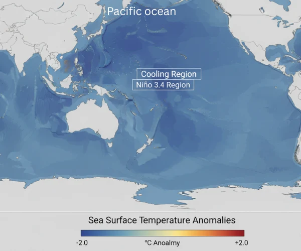
Sea surface temperature anomalies in the Pacific Ocean show rapid cooling in the Niño 3.4 region, signaling the end of El Niño conditions.
“This is one of the fastest transitions we’ve seen in more than a decade,” NOAA scientists said in a recent update.
NOAA: La Niña Has a 70–75% Chance of Taking Over Winter
According to NOAA’s newest ENSO Diagnostic Discussion :
- La Niña conditions are emerging now, as shown in NOAA’s latest La Niña Status and Predictions report.
- There is a high chance La Niña will dominate Dec–Jan–Feb.
- Multiple models show continued cooling into early 2025.
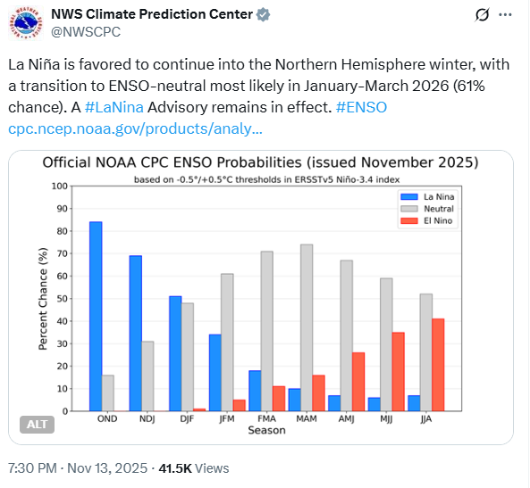
This tweet means the U.S. winter forecast is shifting in real time.
A Classic La Niña Winter Pattern Is Forming
When La Niña forms, the U.S. usually experiences a north–south split in winter weather.
Northern States (Colder + Wetter)
- More snowstorms
- More rain in the Pacific Northwest
- Stronger cold waves from Canada
- Higher chance of blizzards
Southern States (Warmer + Drier)
- Reduced rainfall
- Warmer days and nights
- Higher risk of drought
- Fewer winter storms
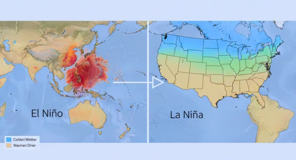
This patterned split is already visible in the latest weather maps.
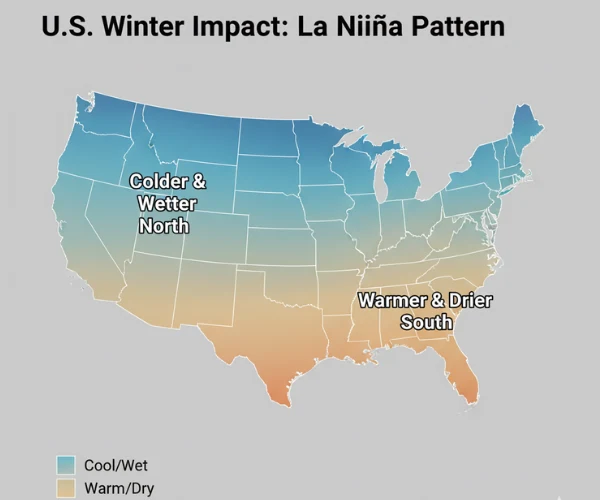
A typical La Niña pattern brings colder and wetter weather to the northern U.S., while the South experiences warmer and drier conditions.
States Expected to Be Hit the Hardest
Meteorologists warn that several states are directly in the path of strong winter activity :
High-Impact States
- Washington
- Oregon
- Idaho
- Montana
- Minnesota
- Wisconsin
- Michigan
- Upstate New York
These regions sit below the strengthened polar jet stream — making them more vulnerable to deep cold, heavy snow, and fast-moving storms.
Early Signals From Local Forecasts
Multiple U.S. states have already updated their winter outlooks based on the new La Niña trend, according to the National Weather Service’s latest winter forecast updates :
- Florida: Warmer winter with fewer cold spells
- Mississippi: Wetter early winter period
- Pennsylvania: Higher snowfall chances after mid-January
- Colorado: Fresh snowstorms expected next week
- Washington & Oregon: Rain-plus-snow mix increasing
These changes appeared within the last 7 days, which shows how quickly the ENSO shift is happening.
Why This ENSO Flip Is Very Different
Scientists say this year’s El Niño → La Niña transition is not normal for three reasons, and NOAA’s ENSO Blog
explains why these shifts have become stronger in recent years.
- Faster Pacific cooling than usual
- Stronger jet stream response
- Extra heat left behind by El Niño
This leftover ocean heat mixes with incoming cold air — creating more powerful winter storms.
“The next 60–90 days could be more active than the last few winters,” a climate forecaster said.
Jet Stream Signals a Busy Winter Ahead
The jet stream is already shifting into a La Niña pattern :
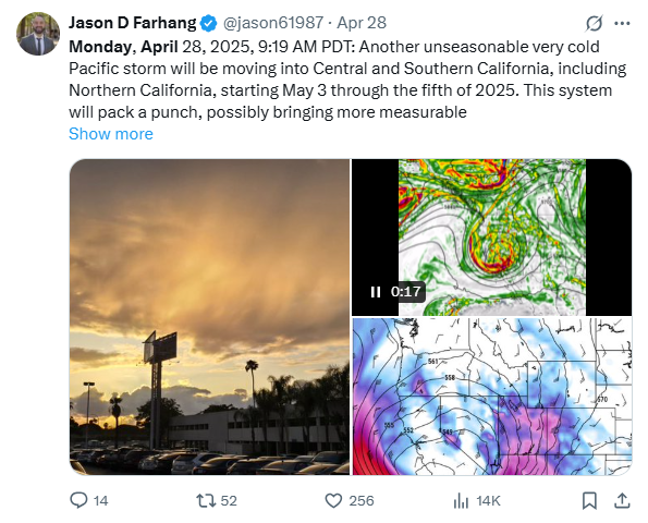
Tweet : Meteorologist Jason Farhang highlights a powerful jet stream pattern driving early-season Pacific storms.
- It is dipping deeper into the northern states
- It is pulling cold Arctic air southward
- Storm tracks are moving across the Midwest & Great Lakes
This could bring :
- Sudden temperature crashes
- Multiple snowstorms
- Fast-forming ice events
- Strong Northwest Pacific systems
Winter Timeline : What to Expect
December : Transition Phase
- Mixed patterns
- Early season snow in the Rockies + Great Lakes
January : La Niña Fully Active
- Strongest storms
- Cold waves
- Heavy snow events
February : Peak Activity
- Blizzard risk increases
- Jet stream remains sharp
- Northern states see biggest snowfall totals
What Residents Should Prepare For
Even though the transition is fast, preparation is simple :
- Keep track of updated local forecasts
- Expect quick weather changes
- Prepare emergency kits (flashlights, batteries, warm clothing)
- For northern states: plan for travel delays
- For southern states: watch drought updates
Final Thoughts
The rapid El Niño to La Niña transition is turning into one of the most important weather stories of the winter season.
- North: Colder, wetter, and stormier
- South: Warmer and drier
- West Coast & Great Lakes: Highest impact
- East Coast: More snow after January
Disclaimer :
This article is based on current climate data, NOAA updates, and available weather forecasts. Actual conditions may change as new reports arrive.

Contents
- 1 A fast and unusual change in the Pacific Ocean is now reshaping the U.S. winter forecast. Scientists say the ongoing El Niño → La Niña transition is happening much faster than expected — and this flip will have serious winter impacts on several states.
- 2 El Niño Is Fading Quickly
- 3 NOAA: La Niña Has a 70–75% Chance of Taking Over Winter
- 4 A Classic La Niña Winter Pattern Is Forming
- 5 Northern States (Colder + Wetter)
- 6 Southern States (Warmer + Drier)
- 7 States Expected to Be Hit the Hardest
- 8 High-Impact States
- 9 Early Signals From Local Forecasts
- 10 Why This ENSO Flip Is Very Different
- 11 Jet Stream Signals a Busy Winter Ahead
- 12 Winter Timeline : What to Expect
- 13 December : Transition Phase
- 14 January : La Niña Fully Active
- 15 February : Peak Activity
- 16 What Residents Should Prepare For
- 17 Final Thoughts
- 18 Disclaimer :