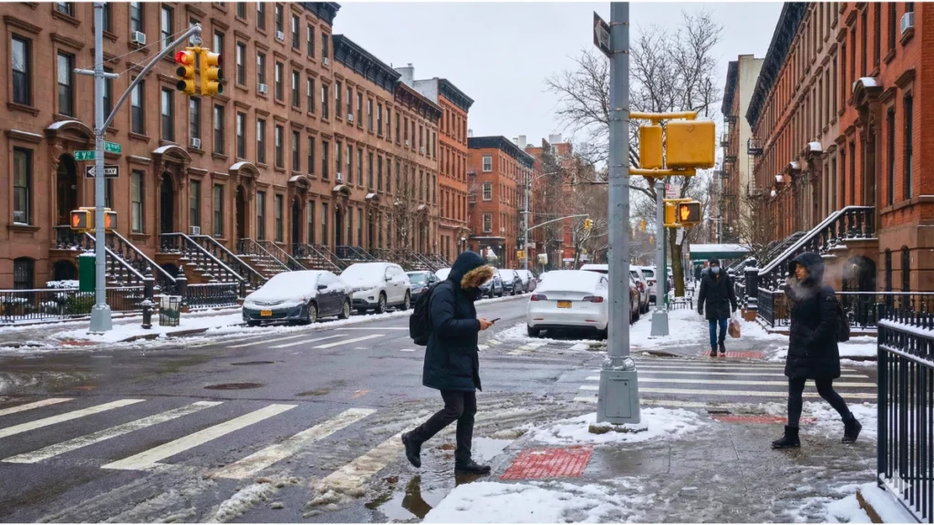
Snow blanketed parts of NYC and the Tri-State overnight as winter arrived early, with colder air set to follow in the coming days.
A quiet Saturday night slowly turned into a full winter scene across New York City and the Tri-State region. When I stepped outside early Sunday morning, the signs were everywhere — snow-covered cars, slippery sidewalks, and a calm that only comes with fresh snowfall.
This marked the first significant snowfall of the season, spreading across New York, New Jersey, and parts of Connecticut. While totals varied by location, the storm clearly signaled that winter has arrived — and colder air is already lining up next.
What Triggered This First Major Snowfall
The snowfall developed late Saturday night and continued into Sunday morning as a winter system moved through the Northeast. Cold air near the surface allowed snow to fall steadily, especially during the overnight hours.
For New York City, this storm was notable because it arrived close to the typical mid-December window for the season’s first measurable snow. Surrounding areas picked up heavier amounts, especially in parts of Long Island, northern New Jersey, and Connecticut, where snow bands lingered longer.
Scientists say these early winter shifts are closely tied to changing global patterns, which we explained earlier in El Niño to La Niña: The Sudden Winter Shift Scientists Say Will Hit the U.S. Hardest.
Why Snowfall Varied So Much Across Short Distances
One of the most noticeable parts of this storm was how uneven the snowfall totals were. Some neighborhoods picked up only a couple of inches, while areas just miles away saw much heavier snow.
This happens when narrow snow bands stall over certain locations. Small changes in wind direction or storm speed can cause snow to pile up in one area while nearby places see lighter amounts. That is why snowfall totals often look very different even within the same city.
Residents also shared real-time views from their neighborhoods as the first snowfall settled in, offering a ground-level look at how winter arrived overnight.
Snowfall Totals Across NYC and the Tri-State
Here’s a simple breakdown of snowfall totals reported across key areas:
| Area | Snowfall |
|---|---|
| Central Park, NYC | Around 2–3 inches |
| JFK Airport | Around 4–5 inches |
| Long Island (parts) | 6–8 inches |
| Northern New Jersey | 4–7 inches |
| Connecticut (select areas) | 3–5 inches |
Some neighborhoods saw steady snowfall for several hours, while others experienced lighter bursts. The difference came down to how long snow bands stayed in place before moving east.
For a wider view beyond the Northeast, our Snowfall Report USA 2025: State-Wise Updates & Highlights tracks how snowfall is shaping up across different states this winter.
Weather officials also shared early snowfall measurements as the storm moved through the region, confirming that accumulations were spreading steadily across parts of New York.
City Response and Travel Conditions
As snowfall began, city crews moved into winter operations mode. Snow alerts were issued, and road treatment started ahead of the heaviest snowfall. Main roads were treated quickly, while side streets took longer to clear.
From what I noticed early Sunday, most highways were moving, but untreated sidewalks and local streets remained slick. Airports across the region also reported delays as crews worked through snow removal and de-icing operations.
For official updates on city preparedness and snow response, information was shared through the City of New York’s sanitation department via nyc.gov, helping residents stay informed about road safety and cleanup efforts.
What This Storm Means for Late December Weather
Forecasters say this storm could be part of a broader winter pattern setting up across the country. While brief warm-ups are still possible, colder-than-average conditions may return more frequently through the rest of December.
If the pattern holds, additional snow events cannot be ruled out before the end of the year. This makes early preparation important, especially for travel plans and daily commutes.
Lingering Ice Could Be a Bigger Issue Than Snow
Even though snowfall has ended, icy conditions may last longer. When temperatures stay below freezing, melted snow refreezes overnight, creating slippery sidewalks and untreated patches on roads.
This can be especially dangerous during early morning and late evening hours. Residents are advised to remain cautious for several days after snowfall, even when streets appear mostly clear during daylight.
What Comes Next: A Cold Wave Moves In
While the snow itself is now winding down, colder air is moving in behind the storm. Forecasts show temperatures dropping sharply over the next few days, with wind chills making it feel even colder.
This type of pattern is common after early-season snowstorms. According to reports from The Weather Channel, Arctic air linked to a broader polar pattern is expected to spread across the region, keeping daytime temperatures low and nights even colder.
The snow on the ground may stick around longer as freezing conditions slow melting, especially in shaded areas.
This colder pattern is not limited to the Northeast, and similar dangerous wind chills have already impacted other parts of the country, as seen in our Sudden Cold Snap Report: Arctic Blast Grips U.S. South and Midwest With Dangerous Wind Chills.
This happens when narrow snow bands stall over certain locations. Small changes in wind direction or storm speed can cause snow to pile up in one area while nearby places see lighter amounts. That is why snowfall totals often look very different even within the same city.
What Residents Should Watch For
As conditions turn colder, residents should keep an eye on:
- Refreezing roads and sidewalks overnight
- Icy patches during morning and evening commutes
- Exposed water pipes during cold nights
- Pets and outdoor animals needing extra protection
Staying alert during temperature drops can help avoid injuries and property damage.
Final Thoughts
This first snowfall felt like a clear turning point for New York City and the Tri-State area. While totals were manageable for most, the colder air arriving next could have a bigger impact on daily life. If this storm is any indication, winter is settling in early — and preparation will matter just as much as enjoying the view.
Disclaimer: Weather conditions can change quickly. This report is based on available forecasts and official updates at the time of publishing. Always follow local authorities and official weather alerts for the latest guidance.

Contents
- 1 Snow blanketed parts of NYC and the Tri-State overnight as winter arrived early, with colder air set to follow in the coming days.
- 2 What Triggered This First Major Snowfall
- 3 Why Snowfall Varied So Much Across Short Distances
- 4 Snowfall Totals Across NYC and the Tri-State
- 5 City Response and Travel Conditions
- 6 What This Storm Means for Late December Weather
- 7 Lingering Ice Could Be a Bigger Issue Than Snow
- 8 What Comes Next: A Cold Wave Moves In
- 9 What Residents Should Watch For
- 10 Final Thoughts