A fast-moving winter storm is disrupting flights, roads, and power lines across the Northeast as millions face snow, ice, and freezing winds.
A Powerful Winter Storm Hits the Northeast
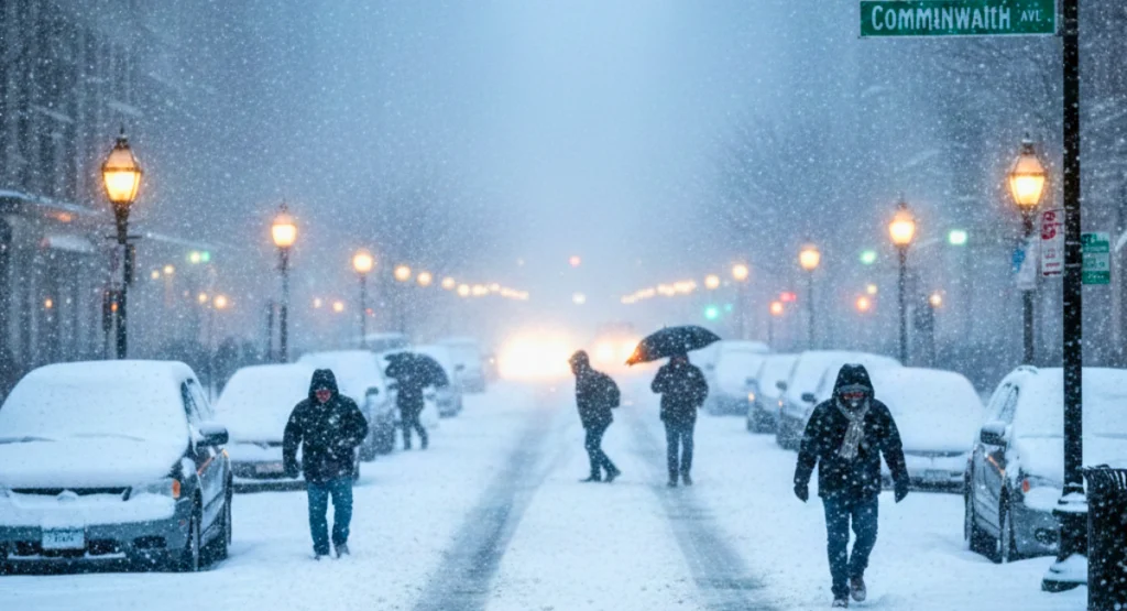
A major winter storm has swept across the Northeast, bringing heavy snow, ice, and strong winds from the Midwest to New England. More than 50 million people are under winter weather alerts, and conditions are changing quickly in several states.
I have been following this system since it started building earlier this week, and the speed at which it strengthened is unusual for early December.
States Under the Highest Impact

Winter Storm Warnings remain active across large parts of the Northeast.
New York
New York is currently under multiple Winter Storm Warnings issued by the National Weather Service, with heavy snow and icy conditions expected across the state.
- Upstate New York is seeing 8–12 inches of snow.
- NYC and nearby suburbs are facing snow + icy mix, causing slick roads.
- Several flights and trains are delayed statewide.
Pennsylvania
- Freezing rain is creating dangerous roads.
- Many regions are dealing with low visibility.
New Jersey
- Ice forming on roads and sidewalks.
- Power lines at risk due to heavy, wet snow.
New England (MA, VT, NH, ME)
- Strong winds up to 40–55 mph.
- Thick snow bands reducing visibility in higher elevations.
Travel Chaos Across the U.S.
Flight Delays and Cancellations
Airports in the Northeast are heavily affected:
- Boston Logan (BOS)
- JFK & LaGuardia (NYC)
- Newark (EWR)
- Philadelphia (PHL)
Over 2,000+ flights delayed were reported across major Northeast airports, according to the latest updates from the Federal Aviation Administration.
Road Conditions
- Multi-vehicle accidents reported on icy highways.
- Snow bands shifting fast make driving difficult.
From what I’ve seen on NOAA radar, snow intensity is changing every hour, especially in New York and Massachusetts.
Transit Delays
- Amtrak is reporting slowdowns on multiple Northeast routes.
- Local subway and bus systems are also affected in some cities.
Power Outages and Infrastructure Risks
Why Power Lines Are in Danger
- Heavy, wet snow sticking to wires
- Strong coastal winds
- Tree branches breaking under snow weight
Areas Already Seeing Issues
- New York, Pennsylvania, and parts of New Jersey have reported outages.
- Utility crews are working in extremely cold and windy conditions.
Why This Storm Is So Strong
La Niña Pattern
This winter season is shaped by a La Niña pattern, which pushes cold Arctic air deeper into the U.S. and increases storm intensity.
Warmer Ocean = More Moisture
The Atlantic is warmer than usual, adding extra moisture and creating stronger snowbands.
Early Season Extremes
This storm is acting more like a mid-winter Nor’easter, even though winter has just begun.
What Happens Next (Next 72 Hours)
Next 24 Hours
- Heavy snow continues in New England
- Ice risk increases in PA, NJ, and MA
Next 48 Hours
- Storm moves offshore
- Lake-effect snow begins in Buffalo, Syracuse, and Great Lakes areas
Next 72 Hours
- Sharp temperature drop
- Flash freeze risk
- Black ice forming on untreated roads
Meteorologists are also monitoring another potential system forming behind this storm.
Safety Tips You Should Follow
For Drivers
- Avoid night driving during snow bands
- Keep blankets, snacks, and a phone charger in your car
- Check local alerts before starting your trip
For Homes
- Charge all devices
- Keep flashlights and warm clothing ready
- Store extra drinking water
Climate Connection: Why Winter Extremes Are Rising
Scientists say winter storms are becoming shorter but more intense because of climate change.
Warmer oceans feed storms with more moisture, and unstable jet streams create rapid temperature swings.
From my experience covering weather events, these patterns are becoming more frequent every year.
What to Expect in the Coming Days
The Northeast should expect continued delays, power risks, and dangerous roads for the next couple of days.
Residents are advised to stay updated through the National Weather Service, local authorities, and official travel alerts.
Disclaimer
This article is based on information from NOAA, the National Weather Service, and publicly available news sources at the time of writing. Weather conditions can change quickly, so readers should rely on official alerts and local authorities for the latest updates and safety instructions.

Contents
- 1 A fast-moving winter storm is disrupting flights, roads, and power lines across the Northeast as millions face snow, ice, and freezing winds.
- 2 A Powerful Winter Storm Hits the Northeast
- 3 States Under the Highest Impact
- 4 New York
- 5 Pennsylvania
- 6 New Jersey
- 7 New England (MA, VT, NH, ME)
- 8 Travel Chaos Across the U.S.
- 9 Flight Delays and Cancellations
- 10 Road Conditions
- 11 Transit Delays
- 12 Power Outages and Infrastructure Risks
- 13 Why Power Lines Are in Danger
- 14 Areas Already Seeing Issues
- 15 Why This Storm Is So Strong
- 16 La Niña Pattern
- 17 Warmer Ocean = More Moisture
- 18 Early Season Extremes
- 19 What Happens Next (Next 72 Hours)
- 20 Next 24 Hours
- 21 Next 48 Hours
- 22 Next 72 Hours
- 23 Safety Tips You Should Follow
- 24 For Drivers
- 25 For Homes
- 26 Climate Connection: Why Winter Extremes Are Rising
- 27 What to Expect in the Coming Days
- 28 Disclaimer